
Glen Nochty – One-Place Study – Tolduquhill
Glen Nochty – One-Place Study – Tolduquhill
Tolduquhill has special meaning for Allanachs as one of the two crofts (along with Aldachuie) that almost every living Allanach can claim connection to.
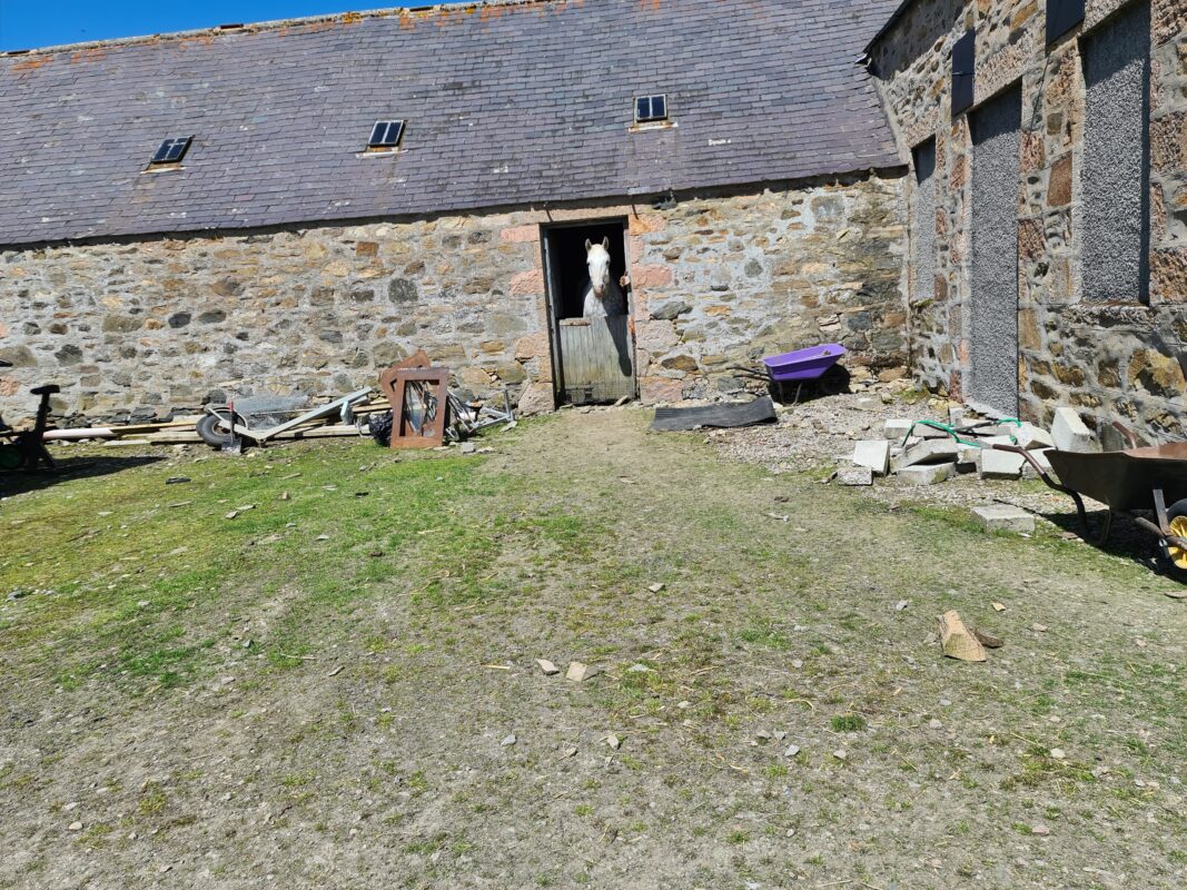
The site was much more extensive that appears today, historically divided into four areas with multiple dwelling places in each. In 1851 there were 22 persons living there, but this has dwindled down to a single family today.
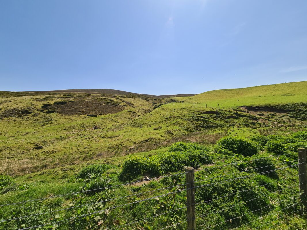
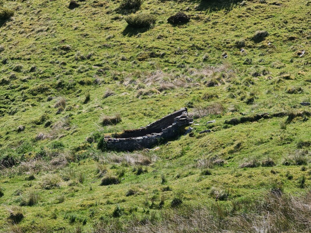
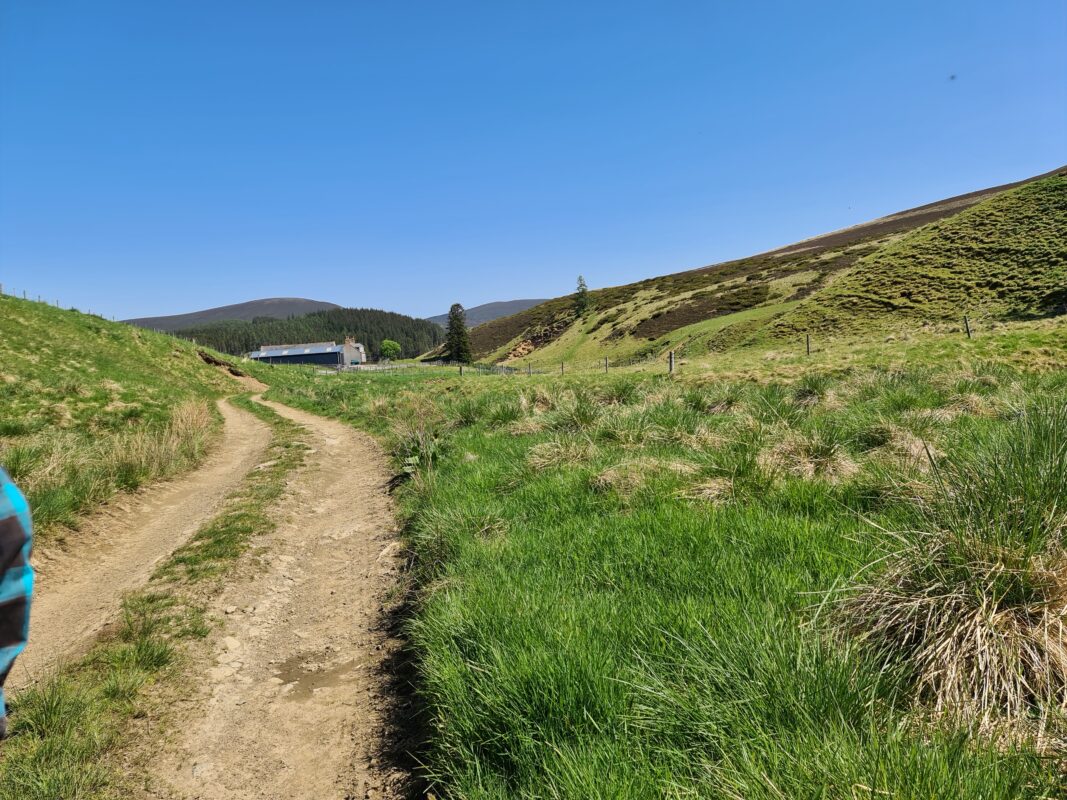
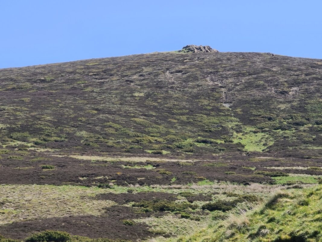
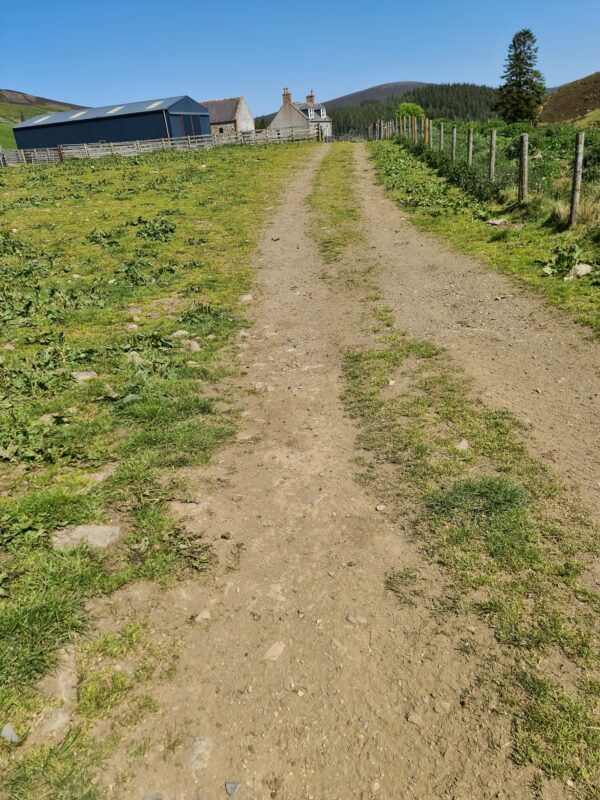
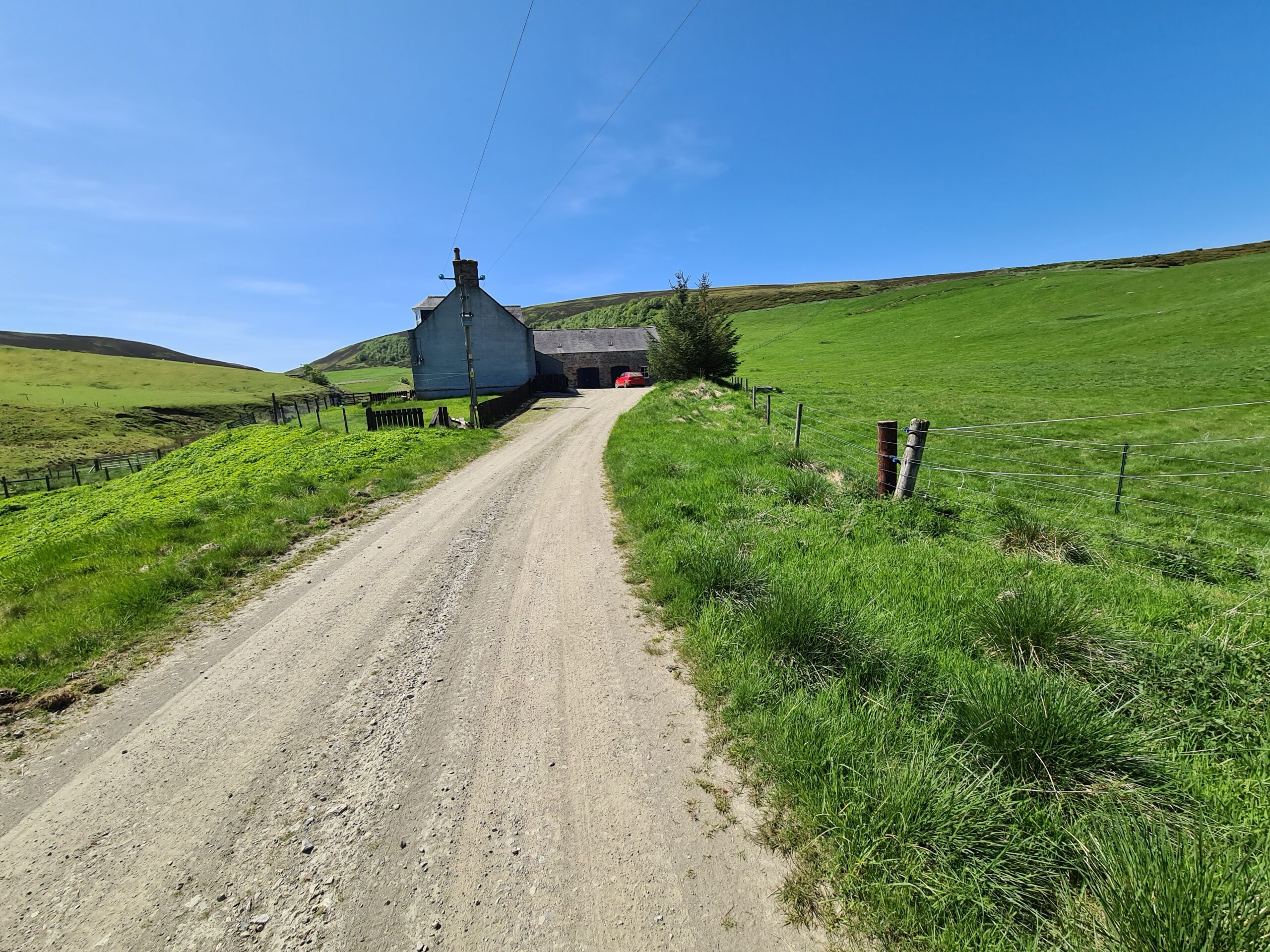
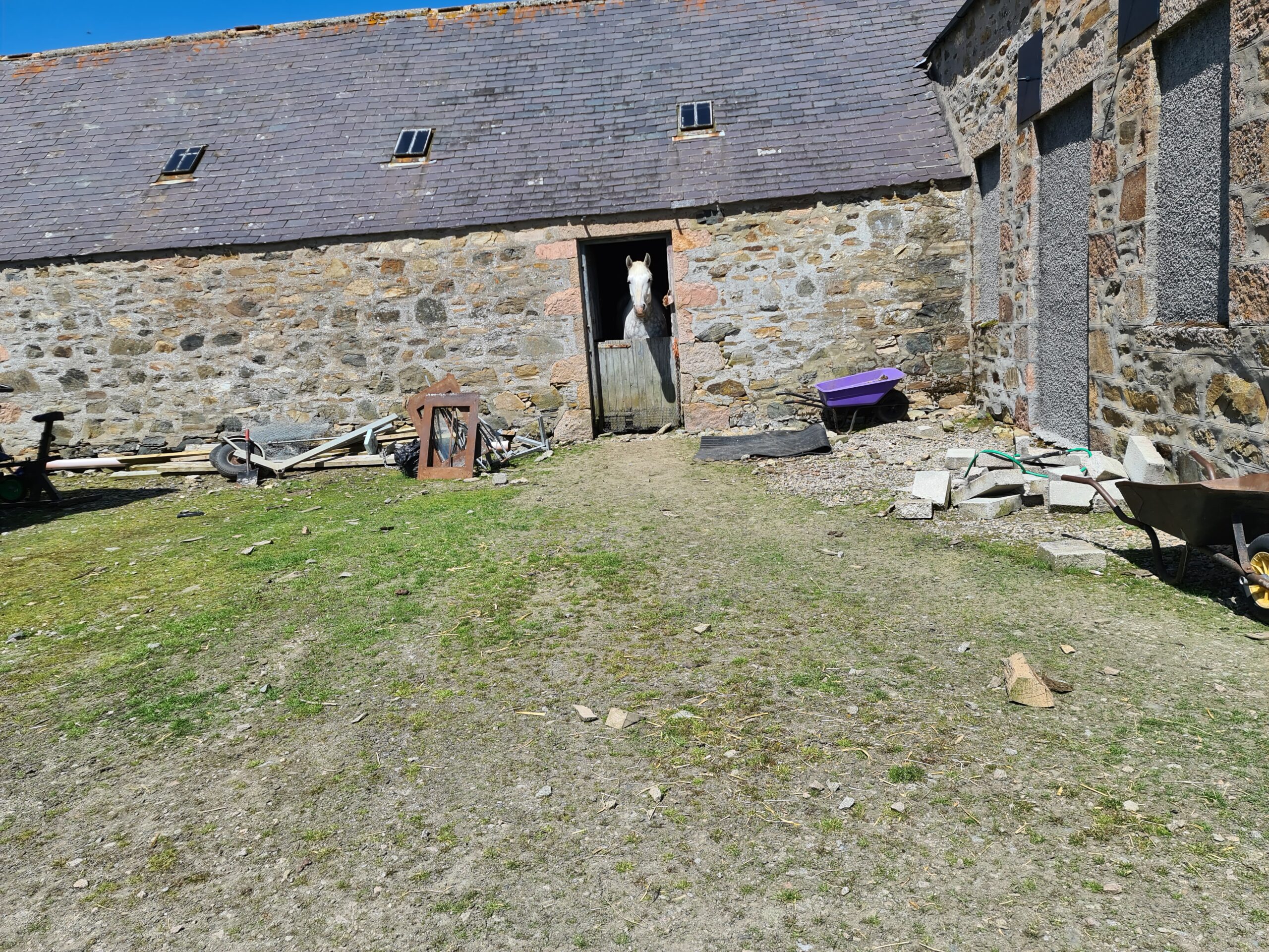
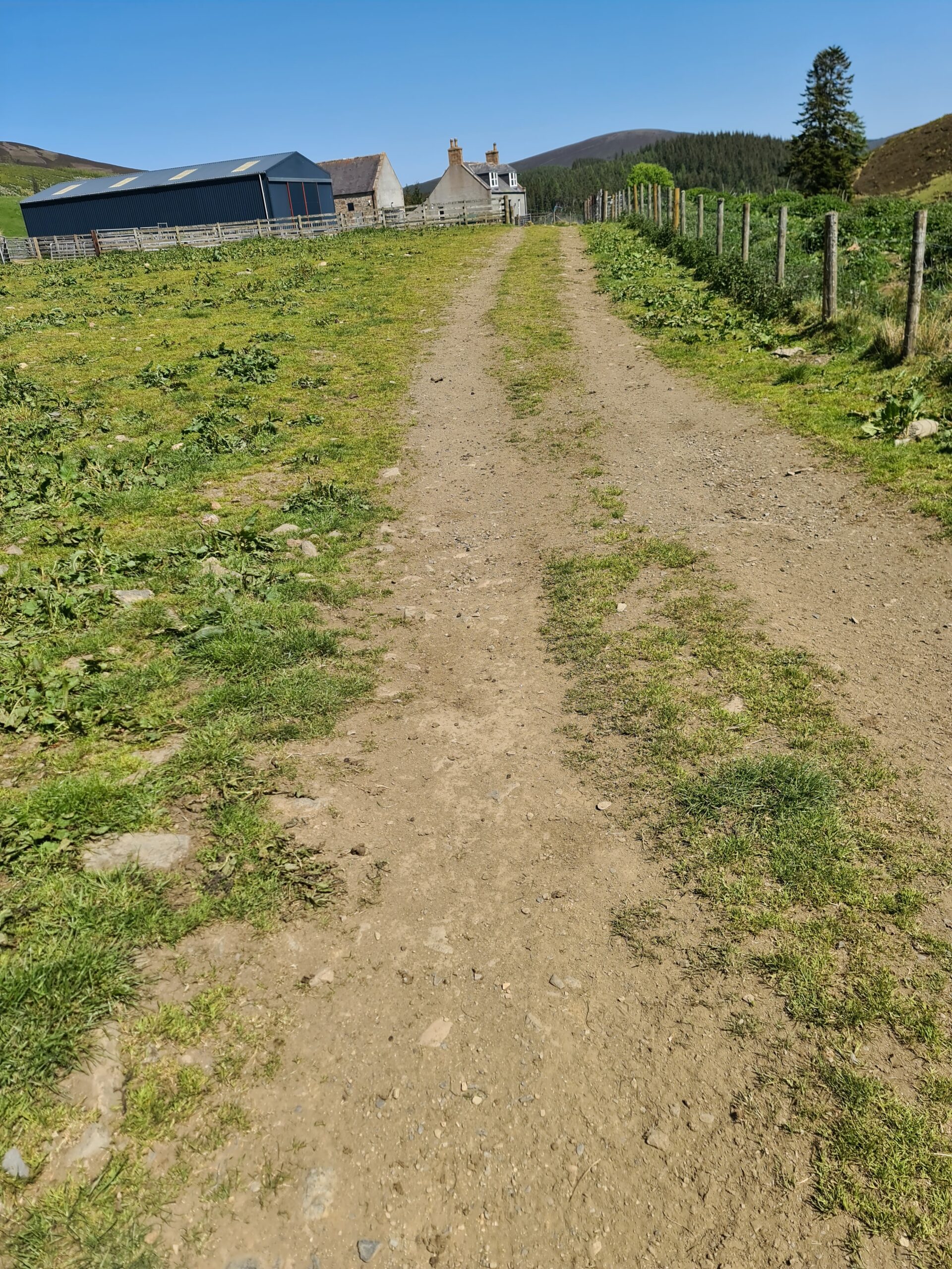
View of site
This 30 second clip should give you an idea of the sites and sounds standing looking towards the site, and hopefully give you a sense of what it is like to be there if you are unable to visit.
General view of site
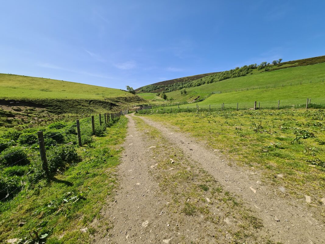
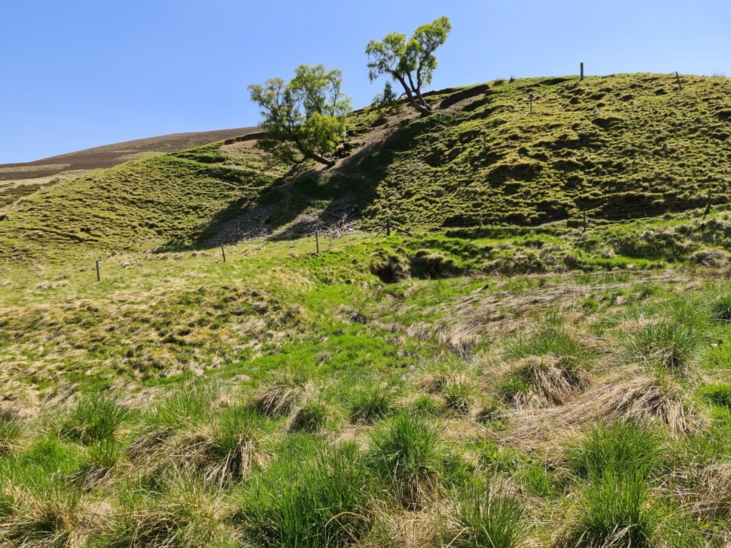
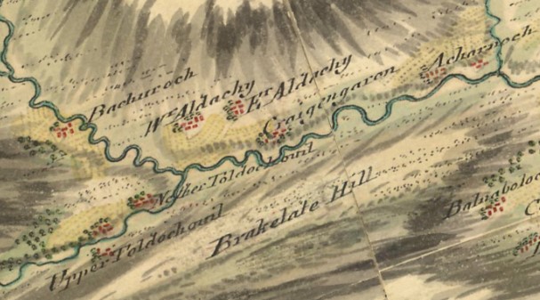
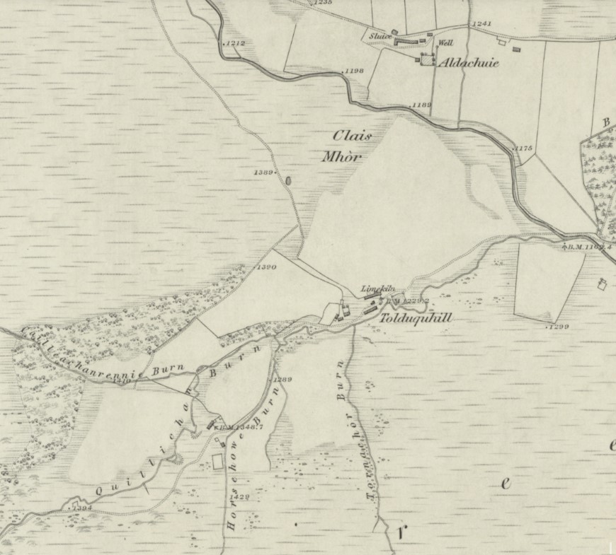
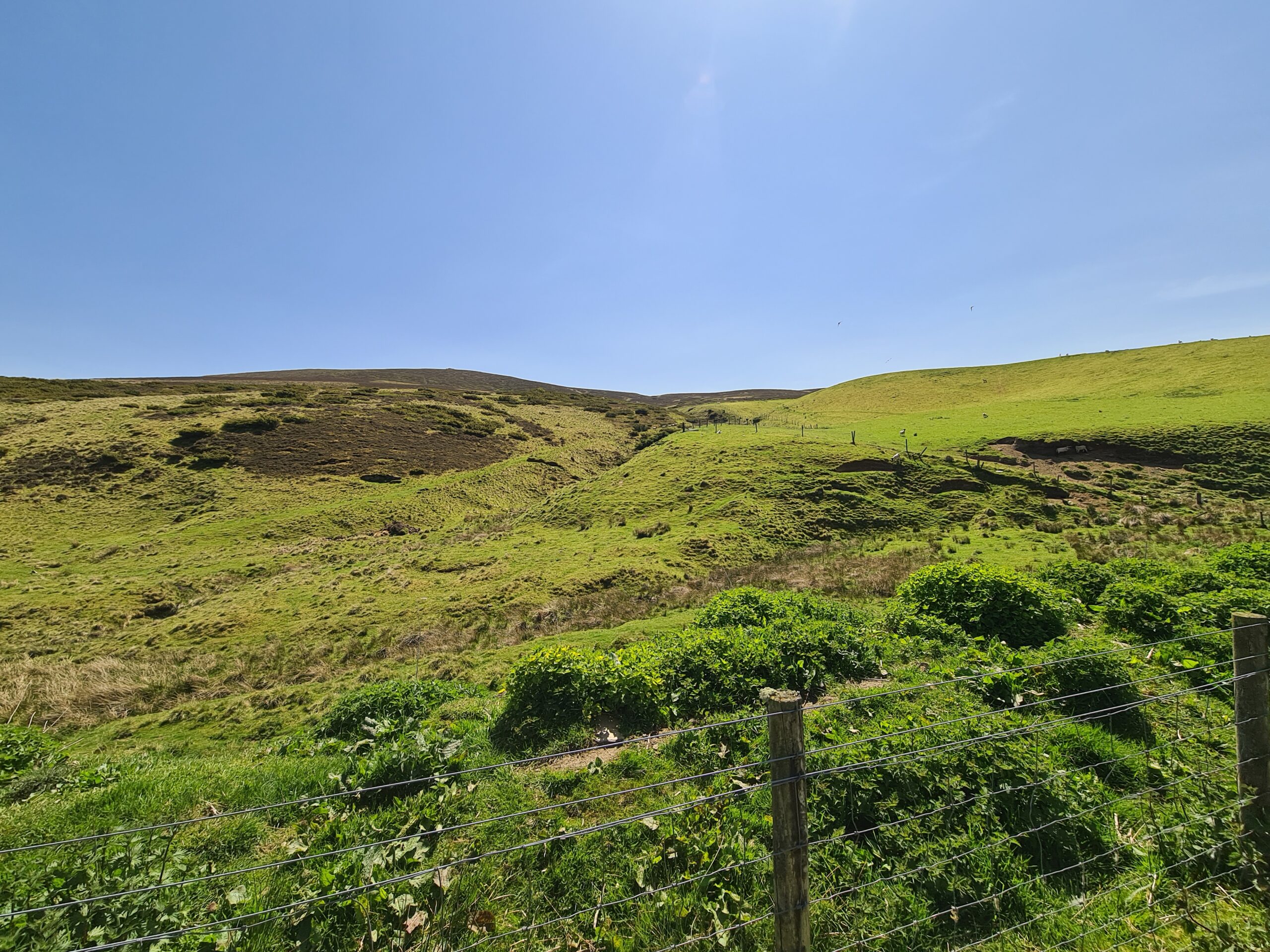
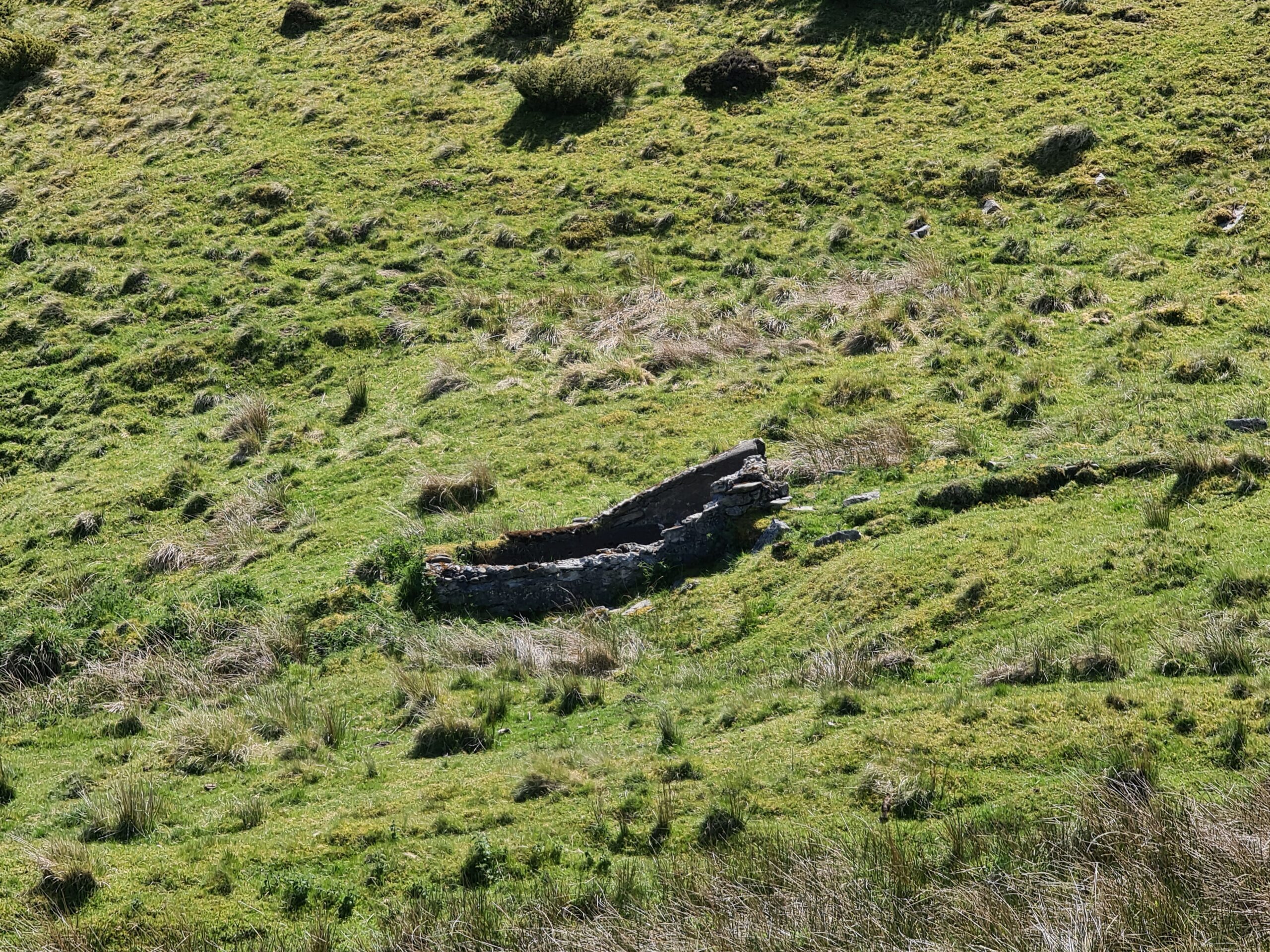
Upper Tolduquhill
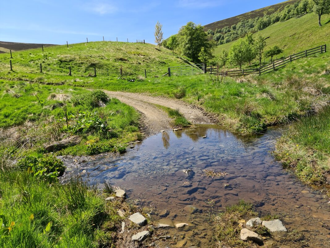
View up Cailleachanrennie Burn
Meaning of name
Tolduquhill
There are many variations in historical records for the name; Tolduquhill, Toldaquhill, Toldoquhill, Toldywhill… For the purposes of this listing, I have used the modern name of Tolduquhill as appears on the OS map today.
There is no explanation provided in the ‘Place Names of West Aberdeenshire’ for the name.
The Ordnance survey name book 1865-1871 has an entry for both Tolduquhill and Quillichan burn. They give their authority as ‘Mr R Farquharson Occupier, Mr C. Farquharson, Occupier’. They state, ‘Name of a farm Consisting of three dwelling houses with office houses and gardens detached situated abt [about] 20. chains Westward of where the Quillichan Burn enters the Water of Noughty The property of Col: [Colonel] Forbes and of the Inverernan Estate.’
“This is a most awkward spelling, but cannot be changed. The accent is on the last syllable & the name is pron’d [pronounced] Toldywhill, while the spelling suggests Tolduwhill. It is therefore not- of the black or dark wood but of the two woods.(?) [Initialled] JMcDT”
This actually makes perfect sense as ‘hollow of two woods/ forests’ in Gaelic would be ‘toll dà choille’.
Quillichan burn
C and R Farquharson in the Ordnance survey name book 1865-1871 state, “a small mountain stream.The issue of which is upwards of a Mile W. [West] of Tolduquhill farm and after Some windings enters the Noughty Water a little E. [East] of the above farm. a portion of which at the issue forms another burn called the Speack which joins the Ernan Water after running abt [about] 2 miles Southward The issue of the Burns of Speack & Quillichan are in the work of completing by Sr. [Sapper] Duncan and his Party.” [Note beside ‘Quillichan Burn’] – Tarsuinn. Across, transversely or obliquely; over, from side to side.
Caochan. A rivulet; an eddy of air; whiskey in its first process of distillation. Described in Sheet 59
Tornachòr burn
C and R Farquharson in the Ordnance survey name book 1865-1871 state, “name of a small Burn which issues from springs abt [about] 15. Chains W [West] from a conspicuous cluster of Rocks on the ph. [parish] boundary Called Reid Crag, and from the Said 15. chains SW [South West] of Reid Craig, it turns northward for about 33. Chains and Enters the Quillichan Burn at Tolduquhill Farm This very common name bears many meanings one of which for Tornachor Hillock with a projecting cliff or rocks in an upper portion of a glen.”
Horsehowe burn
C and R Farquharson in the Ordnance survey name book 1865-1871 state, “received the name, it is said, on account of horses being kept a grazing on and at where the Stream issues forth. It seems down the Slope of the green hill in a northern direction and enters Quillichan Burn about 10. chains above Tolduquhill farm. The property of Col: [Colonel] Forbes.”
Caillechanrennie Burn
C and R Farquharson in the Ordnance survey name book 1865-1871 state, “A mountain stream falling into Quillichan Burn” [Note beside ‘Cailleachanrennie Burn’] – Cailleachan An old woman: (Gaelic)
Locally this name is supposed to mean ” the Cowards’ Burn,” because once on a time there was a fight on Auchernach Hill between the Campbells and the Forbeses, the former being defeated, and many of them slain when trying to escape over this burn. Cailleach means an old woman, and in a figurative sense “a coward”. An alternate explanation is that coileachan (dim. of coileach or caileach, means a small rill), and raineach (fern),” together mean ” ferny rill/ burn”.
Aerial Drone footage
Aerial view of the Tolduquhill site (4k available in settings options)
- Tolduquhill Farm – Gives overview of setting of farm
2. Possible site of Upper Tolduquhill – we visited late May to give the best chance to view any remains of ruins on the ground (no snow and less vegetation). I suspect the two outlines in the ground at 3;59 in the footage and circled in red below could the site of Upper Tolduquhill but will let you make your own minds up!
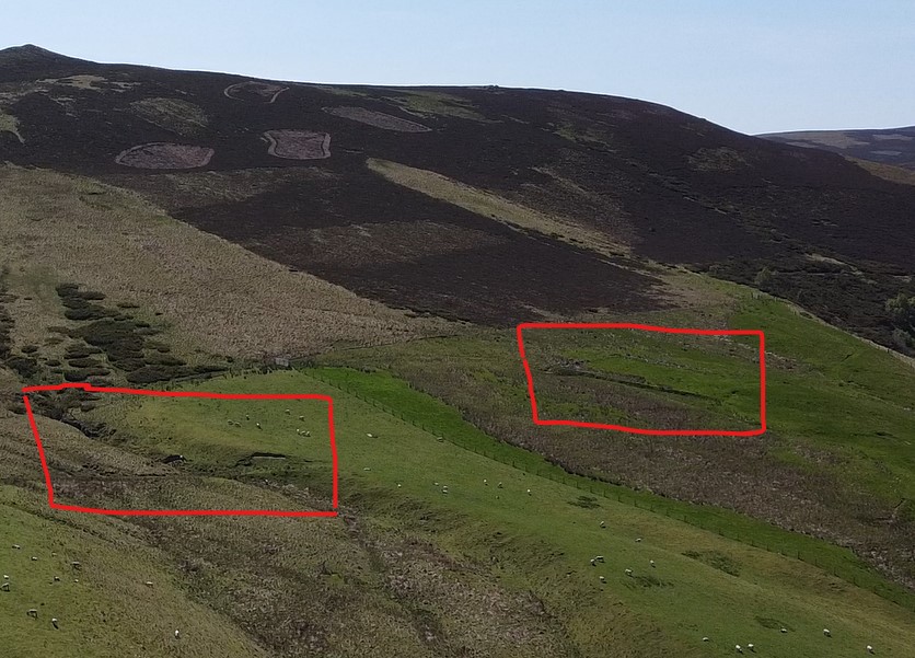
3. Cailleachanrennie Burn
Archaeological notes from Canmore
There are two associated notes/ sites from Canmore listed for Tolduquhill. There also three associated notes for the wider site.
106895 – Lime Kiln (Period Unassigned)
NJ 3127 1525. The remains of a circular limekiln have been noted at an altitude of about 370m OD. Its situation has a S-facing aspect.
NMRS, MS/712/9. The following site has been identified while checking maps held by Grampian Regional Council. Full information is held in GRC SMR.
NJ 312 152. Remains of a lime kiln. Sponsor: Grampian Regional Council. M Greig 1995.
The remains of this limekiln are situated about 70m E of the abandoned farmstead of Tolduquill (NJ31NW 58) and are set into a S-facing slope on the N bank of the Quillichan Burn. The kiln has an overall diameter of 3m, and the bowl, of which only SW half is intact, measures 2m in internal diameter and 1m in depth. Visited by RCAHMS (SPH), 11 June 1997.
126537 – Water Of Nochty, Boundary Stone (19th Century)
This boundary marker is a small upright slab measuring 0.3m in breadth by 0.15m in thickness and 0.4m in height. It bears an incised letter C, representing Candacraig Estate, on its E face, the letter I, representing Inverernan Estate, on its W face, and the number ’10’ on its flat top.
Visited by RCAHMS (SPH), 11 June 1997.
126543 – Tolduquhill – Farmstead (Period Unassigned)
The two main ranges of the farmstead as it is depicted on the 1st edition of the OS 6-inch map (Aberdeenshire, 1869, sheet lx) appear to have been removed to make way for the present farmhouse and steading, which are probably of late 19th century date. The latter is no longer occupied although they are still roofed and in a reasonable state of repair The group of three buildings that formerly stood to the W of the ranges are still identifiable, although the construction of a silage pit has destroyed part of the easternmost, reducing it to little more than a rectangular scoop some 1.5m in depth. The western side of the silage pit incorporates the ENE end of the second building, which measures 11.6m from ENE to WSW by 5.4m transversely over walls 0.8m in thickness and from 0.2m to 0.5m in height. The entrance is probably in the centre of the SSE wall. The third building lies along the edge of the improved field to the W. It measures 21.2m in length from NNE to SSW by 5m transversely over severely robbed walls little more than 0.2m in height along the ESE side and forming a stony scarp about 0.7m in internal height along the WNW side. Traces of at least one partition can be identified, and a faint scar on the NNE possibly indicates that the building extended a further 10m in length at this end. Only the first of these three buildings was still roofed in 1903 (OS 6-inch map, Aberdeenshire, 2nd edition, 1903, sheet lx).
Visited by RCAHMS (SPH), 11 June 1997.
Depicted on the 1st edition of the OS 6-inch map (Aberdeenshire 1869, sheet lx), the group to the W comprises two roofed buildings, one partially roofed and one unroofed building, and the group to the E comprisies four roofed buildings, one of which has a horse engine platform attached.
The current edition of the OS 1:10000 map (1975) shows the western group comprising only one unroofed building and the eastern group has two roofed buildings.
Information from RCAHMS (AKK) 12 April 1999
126557 – Field Boundary (Period Unassigned), Field Boundary (Period Unassigned)
The name ‘Clais Mhor’ (large enclosure) is applied on the current edition of the OS 1:10,000 map (1975) to the NE-facing slope overlooking the Water of Nochty, directly opposite the old farmstead of Aldachuie (NJ31NW 23). The name seems to be associated with the intake NE of Tolduquhill, which is at least partly defined by a turf head-dyke. Measured immediately above the floodplain, this is 2m thick and 0.25m high. The profile of the bank here is slightly asymmetric (the NW flank being the longer), but this may be due to no more than slippage on the steep slope. There is no trace of an accompanying ditch.
The name is also found upon the 1st and 2nd editions of the OS 6-inch map (Aberdeenshire, 1869 and 1903 respectively, sheet lx).
Visited by RCAHMS (ATW; IWF), 4 July 1997
126584 – Cottage (Period Unassigned), Enclosure (Period Unassigned)
(Formerly classified as sheepfold). The remains of a small cottage and enclosure are situated in rough pasture on the right (S) bank of the Water of Nochty. The cottage measures 9m in length from NW to SE by 5.5m transversely within a drystone wall about 0.9m in thickness and up to 0.8m in height where the SW wall acts as a revetment against the slope. A probable outshot at the SE end of the building measures 4m in length. An enclosure lies adjacent to the cottage and extends upslope to the SW. It measures 19m from NE to SW by 15m transversely within a bank derived from an external ditch.
The cottage is depicted as roofed on both the 1st and 2nd editions of the OS 6-inch map (Aberdeenshire,1869 and 1902 respectively, sheet lx).
Visited by RCAHMS (ATW), 11 June 1997.
Further examination of the 1st edition of the OS 6-inch map (Aberdeenshire 1869, sheet lx) depicts the building or cottage as roofless. The pecked outline of the building and the enclosure are shown on the current edition of the OS 1:10000 map (1975).
Information from RCAHMS (AKK) 12 April 1999.
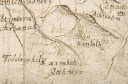
1580 – Pont Map
Amazingly, one of the first maps of Scotland by Pont in 1580 mentions Tolduquhill as ‘Toldawhily’. Alongside is ‘Sloc Moir’ Allt Slochd Chaimbeil (Strathdon). Place names of Western Aberdeenshire has the following informatio, “Burn of the Campbells’ hollow.” The local tradition is that a small party of the defeated army of the Marquis of Argyll took refuge for a time at this place after the battle of Glenlivet, 3rd October, 1594 (O.S., N.B.) This burn joins Allt Slochd Mor, and these together form Nochty Water.”
It perhaps suggest that the Tolduquhill site had greater prominence than might be the case today and might have been a centre for milling, mining or clan/land administration.
1671 – Birth Record
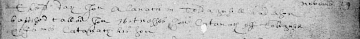
The earliest documented record for Tolduquhill so far found is an OPR for Strathdon showing ‘Jon Alanach’ having a son baptised ‘Jon Alanach’ on the 19th November 1671.
1694 – Land purchase
“In 1694 John Forbes of Inverernan purchased Upper and Nether Tolduchulls from them, including the miln of Tolduchull, which fell into dis-use during the famine of the 1690s” (Aberdeen University MS 3175/M/A93).
1747 – Roy’s Military Map
Roy’s Military mentions Tolduquhill as ‘Toldochoul’ and divides the settlement between ‘Upper’ and ‘Nether’.
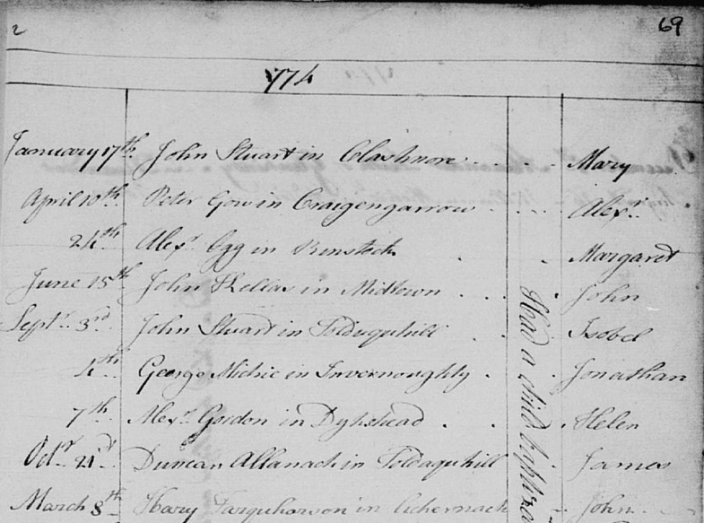
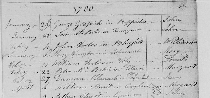
1774 – Birth of James Allanach
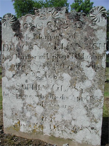
James in 1774 and Jean in 1780 are two of twelve children born to Duncan Allanach and Sophia Glass, either at Tolduquhill or at neighbouring Aldachuie. Duncan and Sophia are the ancestors of the most number of living Allanachs today.
1807 – Death of Duncan Allanach
Duncan Allanach dies in 1807, his grave stating he was a famer in Upper Tolduquhill.
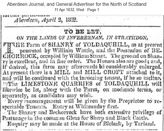
1832 – Newspaper Advert
The limestone quarries of Tolduquhill are to be let.
1841 – Census
The 1841 census states the following individuals as resident in Tolduquhill. (Individual houses marked against persons in bold). Note there is one unoccupied house marked also against Charles Farquharson.
- Robert Dunbar – 30 – Ag Lab
- Jane Dunabr – 25
- Robert Dunbar – 10
- Ann Dunbar – 8
- Elizabeth Dunbar – 5
- Hellen Dunbar – 2
- John McHardy – 40 – Farmer
- Elspit Stewart – 35
- Hellen Stewart – 30
- Margaret Stewart – 30
- Robert Watt – 9
- Charles Farquharson – 30 – Farmer
- Janet Farquharson – 30
- Robert Farquharson – 5
- Hellen Farquharson – 3
- Alexander Farquharson – 1
- Margaret McPherson – 20 – Females Servant (marked as not born in Scotland)
- John Watson – 10 – Male Servant
- Robert Farquharson – 60 – Farmer
- William Farquharson – 27
- Alexander Farquharson – 19
- Diana Farquharson – 55
- Margaret Farquharson – 29
- Katharine Farquharson – 11
1843 – Map
Tolduquhill is featured on the first OS map.
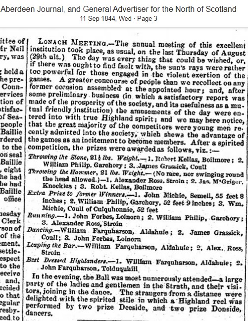
1844 – Newspaper Article
William Farquharson of Tolduquhill wins ‘Best Dressed Highlander’ at the Lonach.
1851 – Census
The 1851 census states the following individuals as resident in Tolduquhill . The enumerator has divided Tolduquhill into four separate areas, each with their own associated dwellings;
- Low Tolduquhill (number 45 headed by Robert Farquharson),
- Tolduquhill (number 46 headed by Charles Farquharson, number 47 headed by Elizabeth Stewart and number 48 headed by Ann Thomson),
- Upper Tolduquhill (number 49 headed by Robert Dunbar and number 50 headed by Hellen McHardy)
- Mill of Tolduquhill (number 51 headed by William Stewart)
- Charles Farquharson – 48 – Head – Ag Lab – POB Strathdon
- Janet Farquharson – 46 – Wife – POB Towie
- Jean Farquharson – 9 – Daughter – Scholar – POB Strathdon
- John Farquharson – 6 – Son – POB Strathdon
- James Farquharson – 3 – Son – POB Strathdon
- Elizabeth Stewart – 54 – Head – Ag Lab – POB Strathdon
- Margaret Stewart – 50 – Sister – Pauper – POB Strathdon
- Ann Thomson – 49 – Head – Pauper (House Servant) – POB Strathdon
- Hellen Essen – 10 – Daughter – At Home – POB Glenmuick
- Robert Dunbar – 42 – Head – Shepherd – POB Strathdon
- Jane Dunbar – 43 – Wife – POB Strathdon
- Ann Dunbar – 19 – Daughter – Servant – POB Strathdon
- Elizabeth Dunbar – 16 – Daughter – Servant – POB Strathdon
- Hellen Dunbar – 11 – Daughter – Scholar at Home – POB Strathdon
- Benjamin Dunbar – 8 – Son – Scholar – POB Strathdon
- James Dunbar – 5 – Son – POB Strathdon
- Jane Dunbar – 3 – Daughter – POB Strathdon
- Hellen McHardy – 48 – Head – Widow – Pauper (Ag Lab) – POB Strathdon
- John McHardy – 9 – Son – Scholar at Home – POB Strathdon
- Hellen McHardy – 6 – Daughter – Scholar at Home – POB Strathdon
- William Stewart – 60 – Head – Ag Lab – POB Strathdon
1854 – Newspaper Article
Robert Farquharson of Tolduquhill is mentioned as executor of a will, regarding the building of a bridge over the River Don.

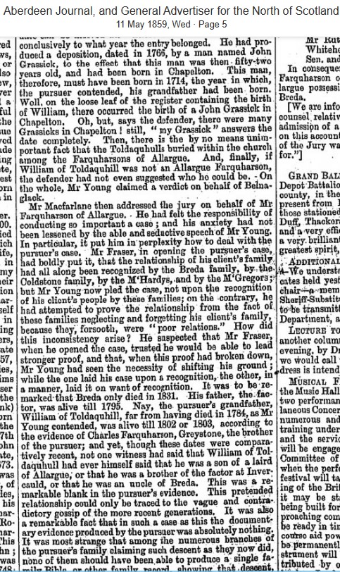
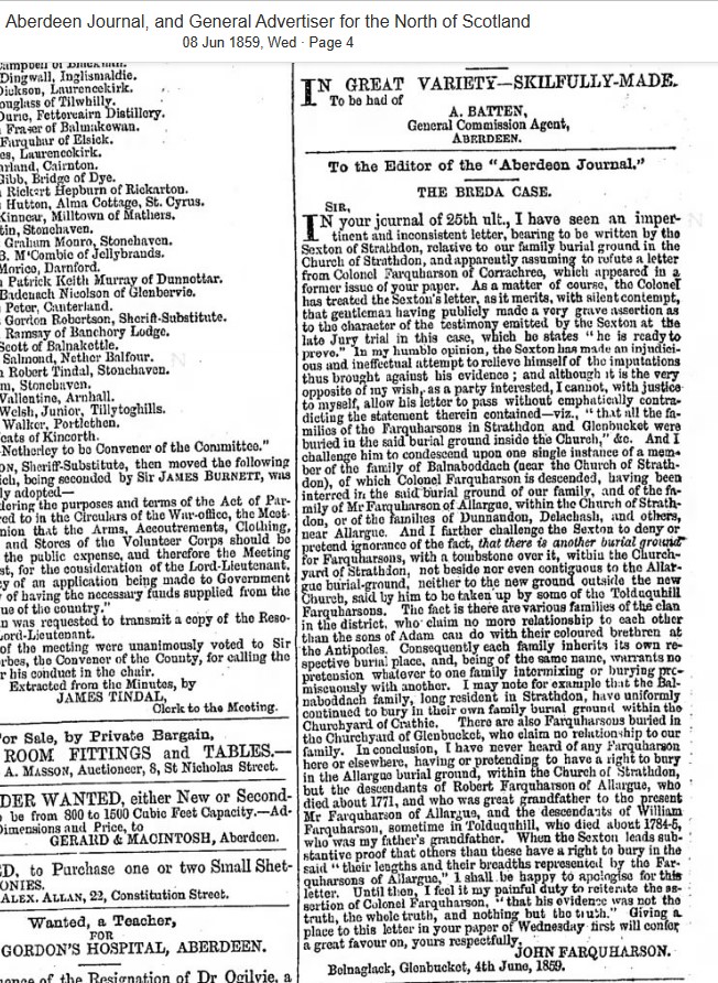
1859 – Newspaper Article
A bitter family dispute about the ‘Breda Case’ sees angry letters sent to local newspapers.
1861 – Census
The 1861 census states the following individuals as resident in Tolduquhill. The enumerator has divided Tolduquhill into three separate areas, each with their own associated dwellings;
- Upper Tolduquhill (number 39 headed by William Farquharson, number 40 headed by Hellen McHardy and number 41 headed by Elspit Stuart),
- Nether Tolduquhill (number 42 headed by Charles Farquharson and number 50 headed by William Farquharson)
- Millfold of Tolduquhill (shown as uninhabited)
- William Farquharson – 51 – Head – Ploughman – POB Strathdon
- Ann Farquharson – 37 – Wife – POB Clatt
- Jean Farquharson – 11 – Daughter – Scholar – POB Gartley
- Christina Farquharson – 9 – Daughter – Scholar – POB Gartley
- Alexander Farquharson – 6 – Son – POB Auchindoir
- Robert Farquharson – 2 – Son – POB Strathdon
- Hellen McHardy – 56 – Head – Shepherd’s Widow – POB Strathdon
- Elspit Stewart – 64 – Head – Pauper (Ag Lab) – POB Strathdon
- Charles Farquharson – 58 – Head – Ag Lab – POB Strathdon
- Janet Farquharson – 54 – Wife – POB Towie
- John Farquharson -16 – Son – Farm Labourer – POB Strathdon
- James Farquharson – 13 – Son – Scholar – POB Strathdon
- William Farquharson – 50 – Head – Farmer of 60 acres – POB Strathdon
- Ann Farquharson – 40 – Sister – Housekeeper – POB Strathdon
- Margaret Bremner – 51 – Sister – Farmer’s Widow – POB Strathdon
- Robert Farquharson – 8 – Grandnephew – Scholar – POB Strathdon
- Ann Brodie – 14 – Servant – Domestic Servant – POB Glenbuchat
1871 – Census
The 1871 census states the following individuals as resident in Tolduquhill. The enumerator has divided Tolduquhill into two separate areas, each with their own associated dwellings;
- Upper Tolduquhill (number 49 headed by William Farquharson, and number 50 headed by Helen McHardy)
- Nether Tolduquhill (number 51 headed by Charles Farquharson and number 52 headed by William Farquharson). Note there is also an uninhabited property marked against Nether Tolduquhill
- William Farquharson – 61 – Head – Farm Servant – POB Strathdon
- Ann Farquharson – 47 – Wife – POB Clatt
- Robert Farquharson – 12 – Son – Scholar – POB Strathdon
- John Farquharson – 7 – Son – Scholar – POB Strathdon
- Margaret Farquharson – 2 – Daughter – POB Strathdon
- Hellen McHardy – 67 – Head – Shepherd’s Widow – POB Strathdon
- Charles Farquharson – 68 – Head – Ag Lab – POB Strathdon
- Janet Farquharson – 65 – Wife – POB Towie
- James Farquharson – 23 – Son – Ag Lab – POB Strathdon
- William Farquharson– 62 – Head – Farmer of 120 acres of which 100 arable – POB Strathdon
- Margaret Bremner – 63 – Sister -Housekeeper – POB Strathdon
- Ann Farquahrson – 52 – Sister – General Serv Domestic – POB Strathdon
- Robert Farquahrson – 15 – Servant – Farm Servant – POB Strathdon
- Louisa McHardy – 15 – Servant – Domestic Servant – POB Glenbuchat
- William Duncan – 7 – Servant – Cowherd – POB Aberdeen
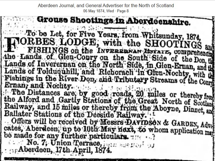
1880 – Newspaper Advert
Grouse Shooting and fishing rights are to be let for 5 years for Tolduquhill and neighbouring Righorach.
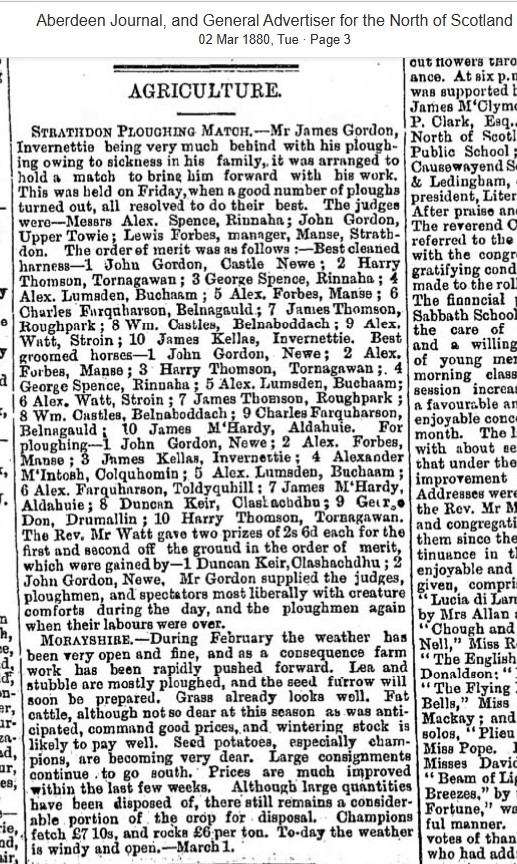
1880 – Newspaper Article
Alexander Farquharson comes 6th at ploughing in a competition held in March.
1881 – Census
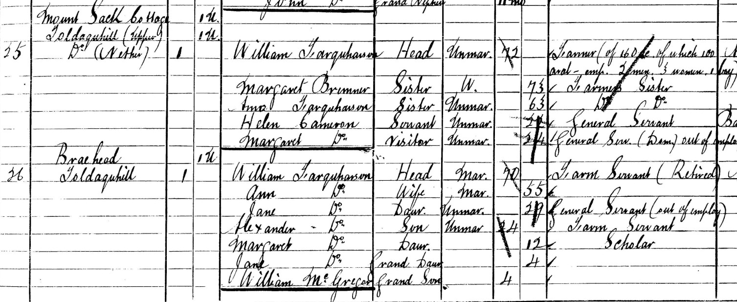
The 1881 census states the following individuals as resident in Tolduquhill. The site now has two listing but with also three uninhabited dwellings, including for names not previously listed – Braehead and Mount Sack Cottage (as shown below).
Note there is also a separate ‘Millfold’ listing which may belong to the Tolduquhill site but research still progressing.
- William Farquharson – 72 – Head – Farmer of 160 acres of which 100 arable – POB Strathdon
- Margaret Bremner – 73 – Sister – Farmer’s Sister – POB Strathdon
- Ann Farquharson – 63 – Sister – Farmer’s Sister – POB Strathdon
- Helen Cameron – 22 – Servant – General Servant – POB Inveravon, Banffshire
- Margaret Cameron – 24 – Visitor – General Servant (Domestic) out of employ – POB Inveravon, Banffshire
- William Farquharson – 70 – Head – Farm Servant (Retired) – POB Strathdon
- Ann Farquharson – 55 – Wife – POB Clatt
- Jane Farquharson – 29 – Daughter – General Servant (out of employ) – POB Gartly
- Alexander Farquharson – 24 – Son – Farm Servant – POB Auchindoir
- Margaret Farquharson – 12 – Daughter – Scholar – POB Strathdon
- Jane Farquharson – 4 – Grand-daughter – POB Glenbuchat
- William McGregor – 4 – Grandson – POB Strathdon
1891 – Census
The 1891 census states the following individuals as resident in Tolduquhill. There are two dwellings listed under ‘Tolduquhill’; number 25 headed by Ann Farquharson and number 26 headed by and Peter Nicole. Note again there is also a separate ‘Millfold’ listing which may belong to the Tolduquhill site but research still progressing.
- Ann Farquharson – 66 – Head – Living on Private Means – POB Clatt
- Alexander Farquharson – 34 – Son – Farm Servant – POB Auchindoir
- Jane Farquharson – 40 – Daughter – Domestic Servant – POB Gartly
- William McGregor – 14 – Grandson – Scholar – POB Strathdon
- Robert Farquharson – 9 – Grandson – Scholar – POB Inveravon, Banffshire
- Alexander F Anderson – 9 – Grandson – Scholar – POB Strathdon
- James Glennie – 4 – Grandson – POB Strathdon
- William McGregor – 1 – Grandson – POB Strathdon
- Peter Nicole – 47 – Head – Farmer – POB Glenmuick
- Jane Nicole – 31 – Wife – Farmer’s Wife – POB Birse
- Peter Nicole – 2 – Son – POB Strathdon
- William Nicole – 11 months – Son – POB Strathdon
- John Nicole – 17 – Nephew – Farm Servant – POB Glenmuick
- Helen George – 27 – Servant – General Servant (Domestic) – POB Strathdon
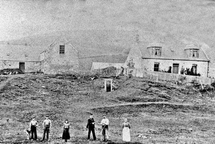
1901 – Family Portrait
The photo below is said to have been taken in 1900. If correct, it is likely to show Peter and Jane Nichol and their family.
1901 – Census
The 1901 census states the following individuals as resident in Tolduquhill. There is now just a single dwelling listed
- Peter Nicol – 57 – Head – Farmer – POB Glenmuick
- Jane Nicol – 42 – Wife – POB Birse
- Peter Nicol – 12 – Son – Scholar – POB Strathdon
- Alexander Nicol – 8 – Son – Scholar – POB Strathdon
- George Nicol – 4 – Son – POB Strathdon
- James Nicol – 3 – Son – POB Strathdon
- Jane Nicol – 4 – Daughter – POB Strathdon
- Jane Cameron – 14 – Servant – General Servant (Domestic) – POB Tarland
- Robert Farquharson – 19 – Servant – Ploughman – POB Inveravon, Banffshire
- William McConach – 15 – Servant – Cattleman – POB Strathdon
1911 – Census
The 1901 census states the following individuals as resident in Tolduquhill. There is now just a single dwelling listed.
- John G Sharp – 40 – Head – Farmer – POB Cabrach, Banff
- Annie Sharp – 31 – Wife – POB Glenbuchat
- Charles Esson – 21 – Servant – Horseman – POB Ballater
- Nellie Reid – 17 – Servant – General Domestic – POB Strathdon
1921 – Census
The 1921 census states the following individuals as resident in Tolduquhill.
- Francis Stewart– 25 – Head – Farmer – POB Strathdon
- Helen Stewart– – 26 – Wife – POB Glengairn
- Baby Stewart – 2 months – Son – POB Strathdon
- George Cameron – 17 – Servant – Ploughman – POB Glenbuchat
- Marjory Duncan – 21 – Servant – Housemaid – POB Kintore
1926 – Electoral Roll
The Register mentions the following residents of Tolduquhill.
- William Stewart
1946 – Civilian Residence Register
The Register states no residents of Tolduquhill.
1966 – Electoral Roll
The Register mentions the following residents of Tolduquhill.
- Hector C McDonald
- Hector C McDonald Jun
- Jean McDonald


Family Link to Tolduquhill
Absolutely fascinating work.
Whilst doing the my family tree recently I have traced as far back as my 7× Great Grandfather Alexander McHardy to Upper Tolduguhill in 1771.
In NRS Wills & Testaments Alexander’s will refers to Upper Tolduquhill. From Strathdon Parish Records Alexander married Anne Forbes 18/4/1759. They had a son Edward born 24/4/1761.
For the next five generations the McHardys lived in the glens of Aberdeenshire, living at Corriebreck, Blairnamuick, Largue, Glengairn amongst other locations.